
Tyler ZIP Code Directory Coverage
Texas geographic data identifies 75701 through 75713 as Tyler postal ZIPs, and postal listings also associate 75798 and 75799 with Tyler. The table preserves the limits of the Tyler source material. Route groupings help identify a delivery relationship, but they do not settle whether an individual parcel lies inside the City of Tyler. For several values, the official research did not establish a station or a special-use classification, so exact-address verification remains necessary.
| ZIP | Areas covered | Post office or route | Research note |
|---|---|---|---|
| 75701 | Tyler postal city; grouped with 75707 and 75711 | Tyler or Azalea station association | Postal area is not city-limit proof |
| 75702 | Tyler postal city; grouped with 75704-06, 75708, and 75712 | Tyler 75702 route | Central and north-associated delivery area |
| 75703 | South Tyler postal area; grouped with 75709 | South Tyler Annex association | Postal service area can extend beyond city limits |
| 75704 | Tyler postal city | 75702 route | Confirm each address |
| 75705 | Tyler postal city | 75702 route | May include east or outlying delivery addresses |
| 75706 | Tyler postal city | 75702 route | Verify county and city jurisdiction |
| 75707 | Tyler postal city | 75701 or Azalea route | Exact boundary was not published in the research |
| 75708 | Tyler postal city | 75702 route | Northeast-associated local orientation only |
| 75709 | Tyler postal city | 75703 route | Verify exact address |
| 75710 | Tyler postal city | Not located | Do not label as a normal delivery type without USPS confirmation |
| 75711 | Tyler postal city | 75701 or Azalea route | Exact residential or special status not located |
| 75712 | Tyler postal city | 75702 route | Exact special status not located |
| 75713 | Tyler postal city | Station not located | Postal association only |
| 75798 | Tyler postal city | Not located | Special-use status was not verified |
| 75799 | Tyler postal city | University association reported locally | Verify before treating it as an ordinary delivery ZIP |
The documented Tyler station details are limited. USPS Connect material associates the Tyler station at 2100 W. Martin Luther King Jr. Boulevard with the 75702 route, and the South Tyler Annex at 6722 S. Broadway, Suite 100 with the 75703 route. The research did not produce a complete official station table for every 757xx value. That uncertainty is useful: it marks where the exact USPS result must carry the answer.
Tyler Core Delivery Route Groups
The three documented Tyler route families provide a practical way to organize a Tyler ZIP code directory search. The 75701 family includes 75701, 75707, and 75711. The 75702 family includes 75702, 75704, 75705, 75706, 75708, and 75712. The 75703 family includes 75703 and 75709. These Tyler groupings describe postal delivery relationships, not an official map of neighborhoods, council districts, or parcel lines.
Local orientation references place 75701 in the southern half inside Loop 323, 75702 in the northern half, and 75703 south of Loop 323. They describe 75704 as northwest, 75705 east along Highway 31, 75706 north of Loop 323, 75707 near southwest or Highway 64 east service, and 75708 as northeast-associated. Use that orientation only to frame a postal search. The USPS address result, not a directional shorthand, determines the standardized code for a delivery address.
Note: Route groupings can narrow a search area, but they do not prove that two addresses share a municipal service area.
Tyler Outer Postal Associations
Tyler ZIPs 75710, 75713, 75798, and 75799 need more caution than the core route groups. The available research identifies them as Tyler postal associations but does not verify a complete post-office classification. A South Tyler Annex or University of Texas at Tyler association may appear in service references for some values, yet the source does not establish a universal ordinary-delivery status. Do not turn an incomplete Tyler association into a claim about a specific address.
Postal coding also changes with service design. The useful question is not whether a code sounds like a familiar Tyler neighborhood. It is whether USPS assigns that exact address to that code today. For an older property record, pair the modern postal check with SCAD's situs address and the legal description in the deed. Historic directories and maps may use an older street form or no modern ZIP at all.
Verify a Tyler ZIP by Address
The USPS ZIP Code Lookup is the authoritative Tyler verification path in the research. It offers a search by exact address, a city-and-state search, and a cities-by-ZIP search. USPS also warns that a ZIP result does not confirm that a particular person or organization is at an address. Use standard Tyler address formatting and preserve the returned ZIP or ZIP+4 with the date of the check.
| USPS route | Input | Best use |
|---|---|---|
| By exact address | A complete delivery address | Confirm the standardized ZIP for one location. |
| By city and state | Tyler, Texas | Review the postal ZIP set associated with the city. |
| Cities by ZIP | A ZIP code | Check the postal-city association before relying on a label. |
A ZIP+4 is the added delivery segment within a five-digit ZIP. It improves address precision but still is not a parcel boundary. The postal lookup should come before a property, deed, or city-service search whenever the written address is uncertain.
Finding Records Within a Tyler ZIP
A Tyler ZIP code can organize an address workflow, but the research did not verify a public ZIP-wide person list in SCAD, GIS, or the individual voter screen. SCAD's exact ZIP filter was not exposed, and the Texas individual voter route is by VUID, qualifying driver-license number, or name rather than ZIP. Use a Tyler ZIP to validate geography, then move to the official source that matches the record question.
- Run the exact address through USPS and retain the standardized five-digit ZIP or ZIP+4 result.
- Use the city-and-state mode if only Tyler, Texas is known and several postal codes are possible.
- Check the address in the Smith County Map Site and the Tyler address service to identify the jurisdiction, map context, and parcel route.
- Use SCAD with an owner, situs address, or account clue. Its verified search routes are property-focused, not a documented ZIP-wide filter.
- For association coverage, use the Texas HOA management-certificate search, which accepts city, county, ZIP, and association-type filters, then read the underlying certificate rather than assuming a member list.
The City of Tyler address lookup can return a neighborhood association label, council district, polling place, beat officer, service days, and a mailing address for an entered location. It is a government-service tool, not an identity result. Once the ZIP narrows an area to a particular street, the Tyler street directory has the parcel and deed workflow.
Tyler ZIP Searches and Tax Tools
The Smith County Tax Estimator is a property-tax estimate route, not a documented Tyler ZIP code directory filter. Its visible controls include tax year, county, city, school, junior college, selected other taxing entities, exemptions, and property value. It can provide tax context after a property is identified, but it should not be used to infer a complete postal-area resident list.
Smith County's Tax Estimator and property-search navigation illustrates the separate tax tool that can follow an address or parcel check.
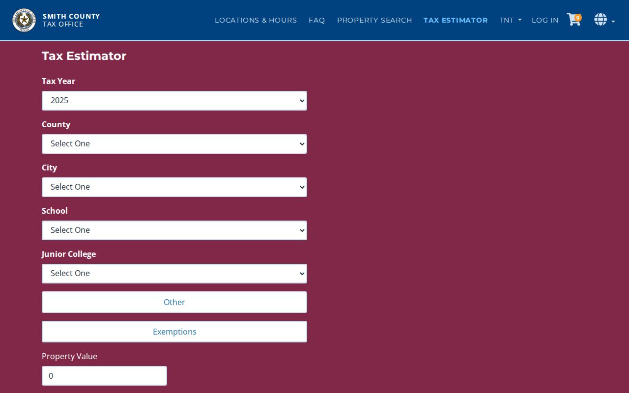
The tool's county, city, school, and exemption controls show why tax geography and a postal ZIP should be kept as different filters.
Tyler ZIP Codes Versus City Limits
ZIP boundaries follow delivery routes. Tyler city limits, the extraterritorial jurisdiction, Smith County boundaries, and 911 address authority follow other lines. A Tyler mailing address may be outside incorporated limits, in a different taxing unit, or served by county 911. Conversely, a parcel inside Tyler may have a postal label that does not match an expected neighborhood name. The correct response is to check the postal result, city address lookup, County Map Site, and SCAD situs together.
Postal limit. A Tyler ZIP code is a geographic and delivery clue, not confirmation that a person or organization occupies an address or that the address sits inside city limits.
The City of Tyler address and service entry point leads to the municipal tools used alongside postal verification.

Use the city result to understand the service and jurisdiction context after USPS supplies the standardized postal address.
Note: Inside Tyler, city GIS answers address questions at (903) 533-2094; outside the city limits, Smith County 911 handles address authority at (903) 566-8911.
Four Tyler Address Keys
Tyler postal research becomes clearer when each address label keeps its own meaning. A Tyler address can appear in a USPS format, as a city or 911 address point, as a SCAD situs, and as a deed legal description. They may line up, but they are not substitutes. The legal description is often the durable bridge when an older document lacks a current street number or when a subdivision name carries the property identity.
- ZIP and ZIP+4
- The five-digit postal code and its added delivery segment used to standardize mail delivery.
- PO-box ZIP
- A postal code associated with post-office-box service; its exact Tyler classifications require USPS verification.
- Unique ZIP
- A code associated with a single institution or special postal arrangement; do not assume one without an exact USPS result.
- Carrier route
- The delivery grouping used by postal service operations, which can cross city or neighborhood expectations.
- SCAD situs
- The physical taxable parcel location used in the appraisal and map system.
- Legal description
- The lot, block, subdivision, survey, abstract, acreage, or metes-and-bounds description in a recorded land instrument.
Tyler ZIP History and Streets
Modern ZIP codes are not the best starting key for a historic Tyler address. Tyler was authorized in 1846 and incorporated in 1850, with an original five-by-four street grid around the public square. The research found a circa-1850 plat and highway maps from 1961, 1972, 1984, and 1987 in the Texas State Archives collection, as well as a digitized 1885 Tyler Sanborn map. Those records can bridge an old street form to a later parcel or directory entry.
The research did not find a verified citywide renumbering or renaming year. Compare the historical plat, Sanborn material, directories, GIS, and Historical Society street files instead of assigning an unsupported date to a number change. For past address occupants, the historical directory collections provide the stronger dated route; postal geography should remain a modern orientation tool.